
Trevor Gray

Josh Krueckeberg
This auction has ended. For information about upcoming auctions or similar properties, please view our upcoming auctions page.
Online Only 4040 1st Pkwy
-
Bidding
- Online Only
- POSTPONED
-
Location
Description
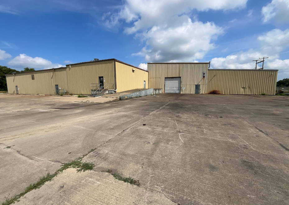
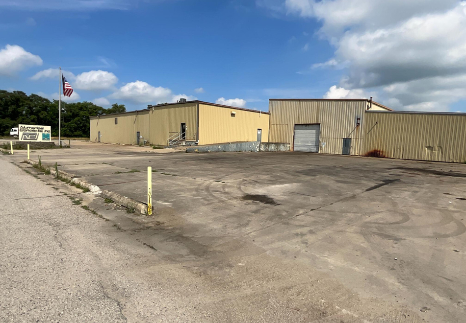
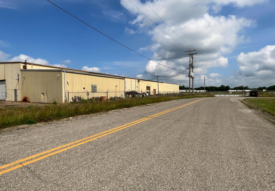
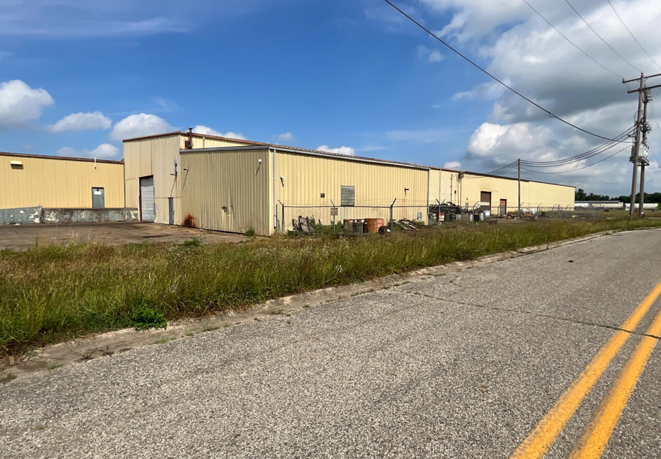
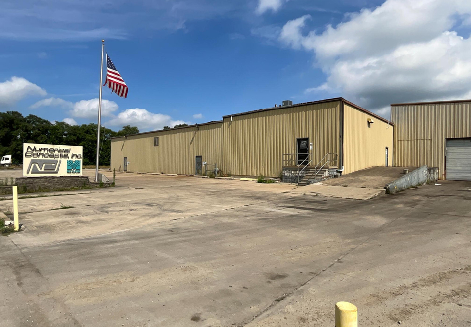
Industrial Real Estate Sherriff Auction
Postponed until further notice!
All Parcels to be purchased as one bid amount located in Vigo County, Harrison Township, Terre Haute, Indiana 47804
74,874 SQ. Feet Building Sitting 12.851 +/- Acres
- Zoned: Industrial M2
- 1 Loading Dock
- (2) 12'x14' Ground Level Overhead Doors
- 480V 3 Phase Power
- Several Bridge Cranes
- Paint Booth
- Office Space
Open House: Tuesday August 12th 9:00 - Noon EST
Parcel I
A part of the Southeast Quarter of Section 1, Township 12 North, Range 9 West, 2nd Principal Meridian, and more particularly described as follows:
Beginning at a bolt and washer in pavement at the Northwest Corner of the Southeast Quarter of Section 1, Township 12 North, Range 9 West, being also the intersection of the center lines of Steelton Road and Fruitridge Avenue; thence along the center line of Fruitridge Avenue, South O degrees, 06 minutes and 10 seconds east 2010.65 feet to a point in said centerline of Fruitridge Avenue; thence North 89 degrees and 45 minutes East 1072.4 feet to a point (being the beginning point of this described tract); thence continuing North 89 degrees and 45 minutes East 233 feet to a wooden stake; thence North O degrees and 15 minutes West 920 feet to a wooden stake; thence South 89 degrees and 45 minutes West 233 feet to a wooden stake; thence South O degrees and 15 minutes East 920 feet to a wooden stake and place of beginning.
Parcel II
A part of the Southeast Quarter of Section One, Township 12 North, Range 9 West, 2nd Principal Meridian, Harrison Township, Vigo County, within the corporate limits of the City of Terre Haute, Indiana, and being more particularly described as follows:
Commencing at the Northwest corner of the Southeast Quarter of Section One as monumented by a bolt and washer of record in bituminous pavement; thence S 0° 06' 10" E (record bearing and basis for bearings cited herein), along and with the West line of the Southeast Quarter of Section One, also being the centerline of Fruitridge Avenue, a distance of 2028.24 feet to a point located N 0° 06' l0" W 613.07 feet from a capped iron pipe monumenting the Southwest corner of the Southeast Quarter of Section One; thence S 89° 57' 10" E a distance of 36.29 feet to an iron pin with aluminum cap on the east right-of-way line, of Fruitridge Avenue; thence continuing S 89° 57 10" E a distance of 410.21 feet to the point of intersection of the centerline of First Street and Aberdeen Avenue; thence continuing S 89° 57’ 10” E (Record S 89° 57' 50" E), along and with the centerline of First Street, a distance of 625.96 feet to the point of beginning; thence N 0° 15' 00" W a distance of 23.15 feet to the Southwest corner of the 4.93 acre parcel conveyed to Robert M. Jones and Jane K. Jones, husband and wife (Deed Record 359, Page 432, Vigo County Recorder's Office); thence continuing N 0° 15' 00 W (Record N 0° 15' W), along and with the West boundary of the aforesaid Jones parcel, a distance of 920.00 feet (Record 920 feet) to the northwest corner of said Jones parcel; thence continuing N 0° 15' 00” W a distance of 31.88 feet to the south boundary of that 8.68 acre parcel conveyed to Illiana Commercial Warehouse and Development Corporation (Deed Record 382, Page 110-1, Vigo County Recorder's Office); thence Southwesterly, along and with the South line of the aforesaid Illiana Commercial Warehouse property, on a non-tangent curve being concave to the Northwest and having a radius of 843.88 feet (Record 843.88 feet), a distance of 118.52 feet (chord distance of 118.43 feet on a bearing of S 57° 21' 24" W); thence S 0° 15' 00" E a distance of 911.07 feet; thence S 89° 57’ 10” E, along and with the centerline of First Street, a distance of 100.00 feet to the point of beginning, containing 2.161 acres, more or less.
Subject to a road easement of 30.00 feet in uniform, perpendicular width off of the entire South side hereby reserved for future dedication to the public.
Parcel III
A part of the Southeast Quarter of Section 1, Township 12 North, Range 9 West, 2nd Principal Meridian, Harrison Township, Vigo County, Indiana, said property being described as follows:
Commencing at the Northwest Corner of the Southeast Quarter of Section 1; thence S 0° 06' 10” E (record bearing) along and with the West line of the Southeast Quarter of Section 1 (Centerline of Fruitridge Ave.) a distance of 2,028.24 feet to a point; thence S 89° 57’ 10” E, a distance of 1,072.46 feet to an iron pin with aluminum cap (said point being the Southeast comer of tract of land used as survey control for this tract of land); thence continuing S 89° 57' 1 O" E, a distance of 233.0 feet to a railroad spike, and the point of beginning; thence continuing S 89° 57’ 10” E a distance of 57.51 feet to an "X" chiseled in the concrete base at First Street and Detroit Avenue; thence N 0° 05’ 30” E a distance of 242.62 feet to a railroad spike; thence N 89° 27’ 50” E, a distance of 150.15 feet; thence N 0° 15' 00" W, a distance of 701.18 feet; thence S 89° 45' 00" W, a distance of 208.55 feet; thence S 0° 1 5’ 00” E, a distance of 944.36 feet to the point of beginning, said line being contiguous with the east line of a parcel described in Deed Record 359, Page 432 in the Vigo County Recorder's Office, containing 3.67 acre, more or less.
Subject to a 30.00 foot wide easement granted to the City of Terre Haute for existing and future roadway construction and maintenance along First Street and Detroit Avenue.
Parcel IV
A part of the Southeast Quarter of Section 1, Township 12 North, Range 9 West, Harrison Township, Vigo County, Indiana, more particularly described as follows:
Commencing at a bolt and washer at the Northwest corner of the Southeast Quarter of Section 1, thence S 0° 06' 10" E (recorded bearing) a distance of 2,028.24 feet along and with the West line of the Southeast Quarter of Section 1 (centerline of Fruitridge Avenue); thence S 89° 57’ 10” E, a distance of 1,072.46 feet to an iron pin with aluminum cap; thence N 0° 15' 00" W a distance of 943.15 feet to an existing iron pin, said point being the point of beginning (P.O.B.); thence continuing N 0° 15' 00" W a distance of 31.88 feet to an iron pin with aluminum cap to a point on curve as described in Deed Record 382 Page 110-1; thence N 51 ° 40’ 44” E along a curve to the left, radius of 843.88 feet, 49.26 feet (arc and chord length) to the point of tangency; thence N 49° 59’ 27” E (recorded bearing N 49° 59' 15” E from Deed Record 381 Page 535), a distance of 498.86 feet; thence S 03° 09' 16" E 381.80 feet; thence S 89° 45’ 00” W, 441.55 feet to the point of beginning, containing 2.09 acres, more or less.
Parcel Numbers: 84-06-01-400-005.000-002, 84-06-01-400-035.000-002
Commonly known as 4040 1st Parkway, Terre Haute, Indiana 47804.
Together with rents, issues, income, and profits thereof. Said sale will be made without relief from valuation or and shall be subject to all liens, encumbrances and easements of record not otherwise extinguished in the proceedings known as
Cause 84D02-2404-MF-002686 in the Superior Court of the County of Vigo, Indiana
The Sheriff’s Department does not warrant the accuracy of the street addressed published herein.
View & Bid Through
Additional Information
Bidding Process: This auction will take place via online auction with a soft close, Bidding will be open now until Tuesday August 26th @ 1:00 PM EST, If any bids are placed within the last 5 minutes of the auction, bidding will extend 5 additional minutes until there is 5 consecutive minutes without bidding activity
Said site can be accessed prior to the date of the Sheriff’s Sale for further information and for the placement of early bids. The Sheriff’s Sale/Commercial Auction shall conclude at 1:00 PM on August 26, 2025, provided, however, if competitive bidding is active at 1:00 PM on said date, the competitive bidding will be concluded before the subject real estate is struck off to the highest bidder.
The terms of the Sheriff’s Sale/Commercial Auction, set forth in the aforesaid Order of the Vigo Superior Court are as follows:
- The successful bidder at the Sheriff’s sale will place a non-refundable ten percent (10%) cash deposit with the auctioneer on the date of the auction, no later than 3:30 PM. The successful bidder shall then have a thirty (30) day period to complete payment of the remaining balance to the auctioneer. After such payment is made in full, the successful bidder will receive a Sheriff’s Deed to the real estate.
- The sale shall be absolute, with no contingencies. The Sale is not made subject to financing.
- If the successful bidder fails to close the transaction by paying the purchase price in full within thirty (30) days of the Sheriff’s Sale, said bidder’s ten percent (10%) cash deposit shall be forfeited. In that event, the Auctioneer may request that the next-highest bidder at the Sheriff’s sale purchase the real estate on the same terms as set forth above.
- The Auctioneer shall be responsible for conducting the closing of the Sheriff’s Sale, as the Agent of the Vigo County Sheriff.
Derek Fell, Sheriff of Vigo County
Bruce A. Smith IN# 154-42
Smith & Miller LLP
P. O. Box 387
Bargersville IN 46106
Phone: (812) 882-0222 ext. 1001
Attorneys for Plaintiff
The Sheriff’s Department does not warrant the accuracy of the street addressed published herein.
Auctioneers License: Josh Krueckeberg (AU19800008 AC31500055)
View & Bid Through
Trevor Gray
Josh Krueckeberg
Why Choose Us?
-
Family-Owned Since 1977
-
Nationwide Service
-
Proven Auction Expertise
-
Personalized, Stress-Free Process